
Before the arrival of Europeans to this immediate area, the lands along the Hudson River around present day Albany to the mouth of the Mohawk River at Cohoes were occupied by Native American Indians named Mohicans. (Also spelled: "Mahican").
English explorer and navigator Henry Hudson (who was under contract with the Dutch to find a shorter sea route to Asia by sailing west instead of the long and dangerous route around Africa to reach the trading ports of China, India, and Japan) left port in Holland around April 1, 1609 on his third voyage and sailed north/west across the vast Atlantic Ocean toward the new world called America in a small ship called the Half Moon seeking to discover the shortcut to Asian waters.
In early September, 1609 the Half Moon entered the "North River" as it was referred to on some very early charts, and continued northward until reaching the area around present day Albany where the river began to become very shallow. The little ship anchored near Albany and began to interact and trade with the local Indians who came out to greet him.
By September 18, Hudson accepts an invitation from a chief to eat with him and goes ashore. The natives "killed a fat dog and skinned it in great haste" for dinner. Hudson is invited to stay overnight. Sensing his discomfort, the natives break their arrows and throw them into the fire to indicate their good intentions. But Hudson returns to the ship. He wrote: "The land is the finest for cultivation that I ever in my life set foot upon."
September 20, the mate and four others took the ship's boat upriver to sound for depth to see if the ship could continue its way northward. The men rowed the little boat past land that would later become Colonie and returned to the ship with news that the river above was not deep enough to allow the Half Moon and its crew to continue. Hudson left the river never to return. The North River would eventually take the name of Hudson's River.
When Hudson finally arrived back in Holland, news spread quickly of his discovery of a navigable river stretching 150 miles inland from the ocean land filled with friendly Native Americans, virgin forests as far as the eye could see, cultivated fields, and most importantly; furs. Furs of all types, especially beaver, were in high demand in Europe. The Dutch were determined to take advantage of this new source of furs.
The following year in 1610, another ship sailed from Holland to about near Albany and began trade with the local Indians. By 1614 the Dutch had built a small fort and trading post called Fort Nassau on Castle Island in the Hudson River near Albany. This little site was badly damaged during one of the spring floods of the Hudson.
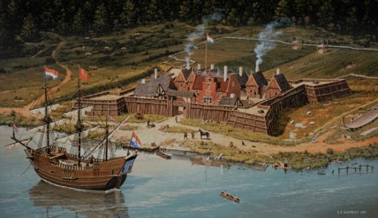
Because the little trading post on Castle Island was seriously damaged by spring freshets and ice jams along the Hudson River, in 1623 the Dutch West India Co. erected another fort on the West Bank of the Hudson River a short distance above Castle Island and named the facility Fort Orange.
Not only were furs of great importance to the Dutch merchants but the Dutch also wished to colonize the area with settlers. By 1629 the Dutch West India Company offered grants and privileges to persons who were willing to travel to the north eastern areas of America called "New Netherland" to establish agricultural Manors consisting of at least 50 persons. By early 1630 Dutch pearl and diamond merchant Kiliaen VanRensselaer desired to establish a Colony (Colonie) around what was then called "Beverwyck" (Albany). By August 1630, VanRensselaer acquired from the Mohican Indians, a tract of land on the west side of the Hudson River from the Normanskill (a stream below Albany) northward to the highly recognized landmark of the Cohoes Falls on the Mohawk River. The land was called the Manor of Rensselaerwyck as seen on early maps.
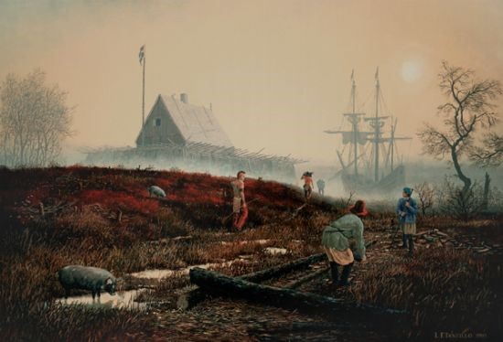
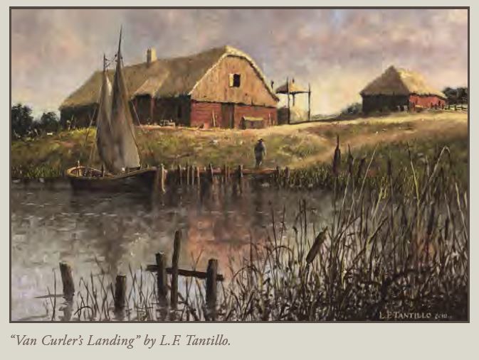
By 1642 the Bowery (Farm) called "The Flatte" about 3 miles north of Fort Orange was acquired by Arent van Curler. VanCurler was a nephew of Kiliaen VanRensselaer who sent him to oversee his interests in his new Colonie or Manor called Rensselaerwyck. In 1643 van Curler wrote an extensive letter to his uncle, Kiliaen van Rensselaer, Patroon of Rensselaerswyck, in response to a letter written by van Rensselaer criticizing van Curler for not protecting his financial interests in the Colonie. In van Curlers response letter he described his activities at the Flatts and an early structure he had built there:
"Last spring I had a house built on this Flatt, 30 feet long, covered with tiles, for the carpenters and the farmhands to live in. [Moreover, I had contracted with Jan Cornelissen, carpenter, for a large farmhouse. He promised to begin it in mid-April. He must build for 700 guilders a house 120 feet] long [by 28] feet wide; 40 feet is [set aside] for dwelling purposes, leaving 80 feet for the Bouwhuys. The dwelling part is to be floored above and below, and he is to build a cellar, [20 feet long] by 28 feet wide; a half-jutting chamber (hangh Camer) for the servants to sleep in; a bunk (kooi) for the foreman in the Bouwhuys; box stalls for the stallions, and further a horse and cow stable and whatever else appertains thereto, and that subject to the inspection of persons conversant with such work and who understand carpentry. The other carpenters would not build it for a thousand guilders, so that he is not very anxious for the job. I let the contract to him while he was sober, in the presence of Domine Jo[hannes]."
A rendition of Van Curler's home at the Flatts was done by Albany Artist Len Tantillo who graciously allowed the Historical Society of the Town of Colonie to use this image on an interpretive sign installed at the site of the Van Curler dwelling at the Flatts in 2015:
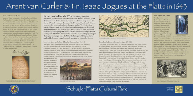
In 1643 Arent van Curler played a major role in providing an escape plan for the French Jesuit Priest Isaac Jogues who had been captured by Mohawk Indians the previous year and held captive by them at their castle in the Mohawk Valley west of Schenectady. It was believed that the Mohawks were planning to kill Fr. Jogues despite an earlier promise not to. Van Curler allowed a group of Mohawk Indians who, along with Fr. Jogues had come to net fish in the Hudson River near Albany, to sleep in his home. Jogues was able to escape his Mohawk captors and eventually make his way back to France. Jogues was later killed by the Mohawks after returning to their Castle in the Mohawk Valley to convert the Indians to Christianity. The site of his murder (martyrdom) is the location of today's Auriesville Shrine near Amsterdam.
Other 17th Century scenes by Len Tantillo related to the Van Curler era at the Schuyler Flatts can be seen by visiting this link.
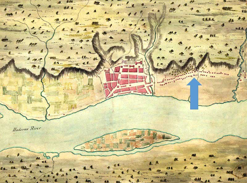
The little Dutch settlement stretching outside the northern end of Fort Orange was referred to as the "Colonie" and is seen (above) on this early map of Fort Orange, now present day Albany. The area indicated by the blue arrow is roughly from present day Clinton Ave. to the Patroon Creek in North Albany seen on the right side of this map.
Watervliet Described:
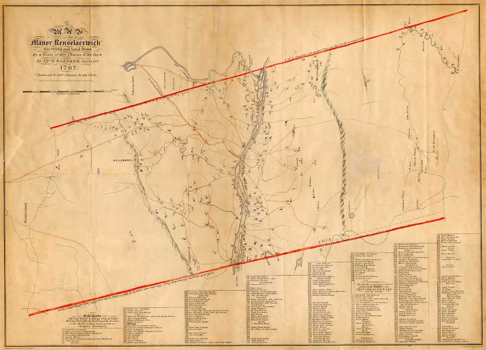
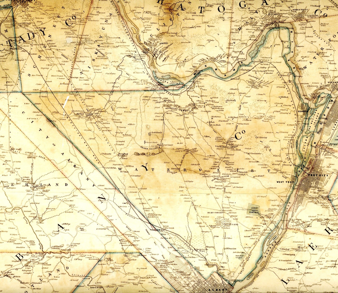
The red lines on this 1767 Map show the boundaries of the Manor of Rensselaerwyck. The northern boundary of the Manor was defined by the landmark Cohoes Falls. On the west bank of the river, this line continued west from the Cohoes Falls along what is now Manor Avenue in Cohoes to the Boght Road in Colonie, and continuing west all the way to the Niskayuna Town Line. On March 24, 1772 the Manor was divided into two districts (east and west) with the Hudson River being the dividing line. The word "Watervliet" is best described in the book: "History of Albany and Schenectady Counties 1609-1886": ---- "The name Watervliet is of Dutch origin, from water and vlatke, level plains or flats. The level lands or flats along the river were and are subject to overflow in time of freshets; hence they are the ‘overflowed flats" or water-vlatke the last word corrupted into ‘vliet' which is incorrect, as ‘vliet' in the Dutch language means river." The original town of Watervliet encompassed all of what is today's Albany County.
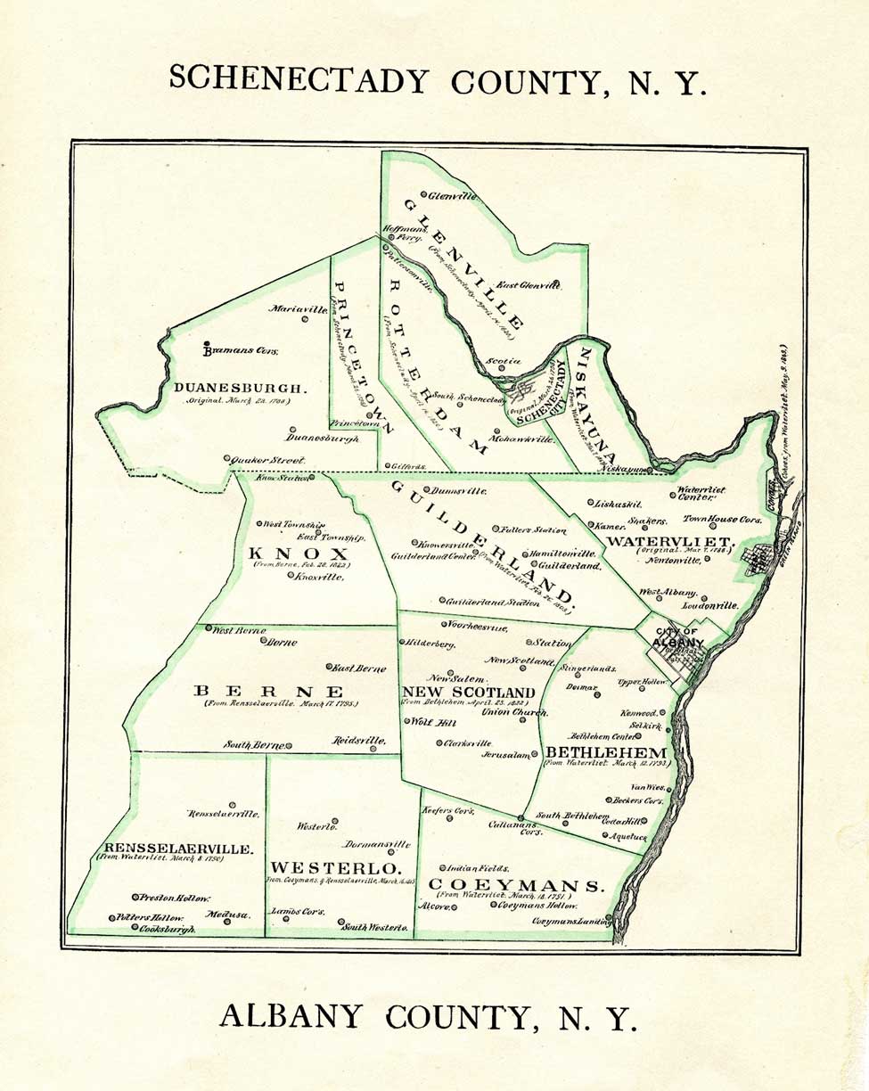
Throughout the very late 18th and early 19th Centuries other towns were formed or "removed from" the larger Township of Watervliet. The first area to declare itself its own town was Rensselaerville. Other towns soon followed. Leaving, by 1886, when this map was published, a sixty square mile of triangular shaped land still called "Watervliet". This map clearly defines the triangular shaped outline of the last section of the old town of Watervliet, or the present day Town of Colonie. See Below:
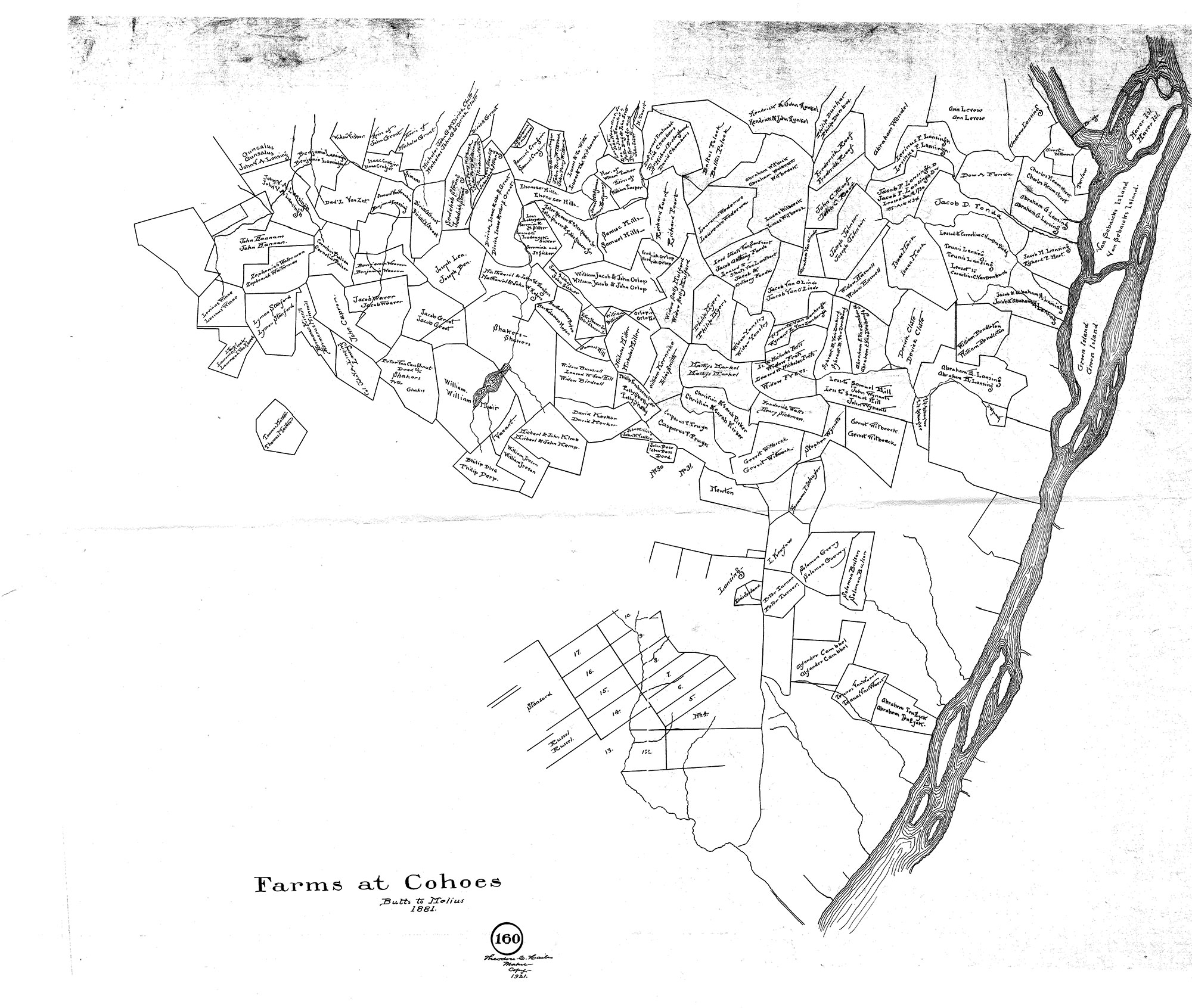
This map called the "Farms at Cohoes" shows the number of tenant farmers in the area of the old Town of Watervliet which later became Colonie by 1895: Names such as Yearsley, Stanford, Whitbeck, Orlop, Fort, and others are seen. Each farmer had to pay Stephen VanRensselaer III, the Patroon of the Manor, an annual rent for their farms. Rents consisted of several bushels of clean merchantable winter wheat, four fat fouls, and a day's work with a team of horses and wagon at the direction of the Patroon. When Stephen VanRensselaer III died in 1839, his sons inherited the entire Manor of Rensselaerwyck and all of the rents associated with the tenant farms on both sides of the Hudson River.
This 1851 (Sidney) map of the old Town of Watervliet gives an idea of what the Town of Watervliet looked like a half century before becoming Colonie in 1895. Its southern boundary, a long straight line leading roughly from the Hudson River all the way to Schenectady County was clearly defined by the long rectangular shaped piece of land being a part of the City of Albany stretching all the way west through what is now called Pine Bush to Schenectady County. An early road established around 1663 called the Kings Highway led from what is now Albany to the new settlement at Schenectady.
By 1895 the now familiar triangular shaped remaining parcel of the once larger Town of Watervliet was still largely rural farm land with the exception of the villages of West Troy and Green Island and the City of Cohoes. Toward the end of the 19th Century the farmers in the rural areas of the town did not feel that the needs of this rural area were being fairly addressed by political powers of the day which were centered primarily in West Troy. The farmers petitioned the legislature to form their own town separate and apart from West Troy and Green Island. The matter was put to a vote by Town residents who approved the separation.
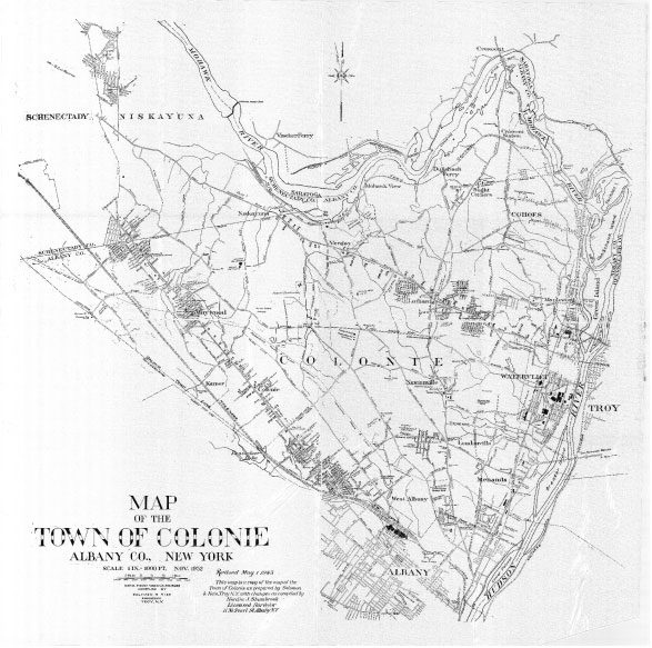
On June 7, 1895 a new town called Colonie was born. Its founders chose to name the new town "Colonie" after the little settlement north of where old Fort Orange stood called the Colonie, which had been annexed into the City of Albany during the early 19th Century. This 1932 map of Colonie by Surveyor Nordin R. Shambrook shows many of the roads and some early developments and hamlets within the town by that time. It was revised in 1943.
A modern map of the Town of Colonie can be found by here.